Wednesday, February 4, 2026
Appalachian News Express
  • Crime
  • News
  • Pikeville News
  • Sports
  • Weather
  • Traffic & Transit
No Result
View All Result
Appalachian News Express
Home Weather

Northern Lights Possible Tonight in Louisville and Central Kentucky Before Tuesday Storms

Justin Begley by Justin Begley
September 3, 2025
in Weather
0
One Hiker Dies After Falling in Kentucky
0
SHARES
2
VIEWS
Share on FacebookShare on Twitter

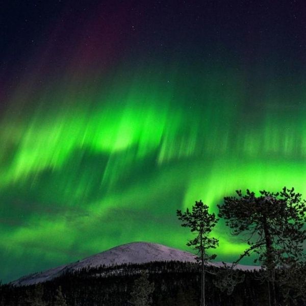
LOUISVILLE, Ky. – Kentucky residents could witness a rare display of the Northern Lights tonight, as clear skies may allow auroras to be visible across Louisville, Jefferson County, and areas along I-64. However, changing weather conditions could bring scattered storms by Tuesday afternoon.

According to NOAA’s Space Weather Prediction Center, a recent solar flare is driving geomagnetic storms strong enough to make auroras visible as far south as Kentucky, Indiana, and Missouri. While tonight offers the best viewing opportunity, increasing cloud cover may limit visibility by late Tuesday.

Related posts

This Article Includes

  • 1 Related posts
  • 2 First Alert Forecast: Heatwave Holds Steady, Only Slim Rain Chances
  • 3 Gov. Beshear Provides Update on Rental Construction After 2021 Kentucky Tornadoes
Two Men Arrested After I-95 Police Chase and Crash in Delaware County

First Alert Forecast: Heatwave Holds Steady, Only Slim Rain Chances

September 16, 2025
Tractor Accidents Claim Two Lives in Michigan and Kentucky

Gov. Beshear Provides Update on Rental Construction After 2021 Kentucky Tornadoes

September 13, 2025

The National Weather Service in Louisville has issued an advisory for isolated thunderstorms after 2 p.m. Tuesday, especially west of I-65, which could bring brief downpours and gusty winds.

Louisville will reach 82 degrees on Tuesday with light south winds. By Tuesday night, temperatures will drop near 60 degrees with a 20% chance of showers. Rain and storm chances increase Wednesday, with scattered showers likely continuing into Thursday. Drivers should be cautious of slick roads along I-64 and I-65 during midweek commutes.

For the best view of the aurora, residents should head to dark, rural locations away from city lights. Officials also recommend keeping phones and devices fully charged in case storms cause power disruptions later this week.

Storm activity is expected to taper off Thursday night, with clearer skies and calmer weather returning Friday and lasting into the weekend. Residents are advised to stay updated on National Weather Service alerts for any midweek storm warnings.

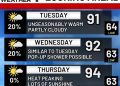
Five-Day Forecast for Louisville, KY

  • Tuesday: High 82° — slight chance of afternoon showers, Northern Lights possible overnight.

  • Wednesday: High 82° — scattered storms, breezy at times.

  • Thursday: High 73° — showers and storms likely, cooler evening.

  • Friday: High 81° — sunny with calm winds.

  • Saturday: High 77° — mostly sunny, pleasant early fall day

This article has been carefully fact-checked by our editorial team to ensure accuracy and eliminate any misleading information. We are committed to maintaining the highest standards of integrity in our content.

Previous Post

7 U.S. States Prepare for Major Cold Front as September Begins

Next Post

Trump Seeks to Cut Affordable Housing Grant Vital to Kentucky Communities

Next Post
One Hiker Dies After Falling in Kentucky

Trump Seeks to Cut Affordable Housing Grant Vital to Kentucky Communities

Leave a Reply Cancel reply

Your email address will not be published. Required fields are marked *

RECOMMENDED NEWS

TDOT Schedules Bridge Inspections, Lane Closures in Rhea and Cumberland Counties Next Week

Two Injured in Single-Vehicle Crash Saturday Morning in Dunlap

5 months ago
Tractor Accidents Claim Two Lives in Michigan and Kentucky

Tractor Accidents Claim Two Lives in Michigan and Kentucky

5 months ago
Central Kentucky Braces for Summer Heatwave with Highs Near 90s Through Monday

IMPD Launches ‘Drive Sober or Get Pulled Over’ Campaign to Fight Drunk Driving

5 months ago
N.C. 12 Reopening After Storm Overwash Cleanup, Speeding Cameras May Be Coming to School Zones

N.C. 12 Reopening After Storm Overwash Cleanup, Speeding Cameras May Be Coming to School Zones

5 months ago

FOLLOW US

BROWSE BY CATEGORIES

  • Crime
  • News
  • Pikeville News
  • Traffic & Transit
  • Weather

POPULAR NEWS

  • D.J. Daniel, Honored by Trump, Sworn In as Honorary WV Police Officer

    KYTC Unveils Plans for New Pike County Road to Bypass Town Mountain

    0 shares
    Share 0 Tweet 0
  • Tennessee Faces Factory Shutdown and 153 Confirmed Layoffs

    0 shares
    Share 0 Tweet 0
  • Chattanooga attorney charged with assault after incident outside East Ridge home

    0 shares
    Share 0 Tweet 0
  • Tennessee Abruptly Loses 3 Factories as Layoffs Multiply

    0 shares
    Share 0 Tweet 0
  • Kentucky Governor Weighs State Police Patrols on Louisville Interstates

    0 shares
    Share 0 Tweet 0
Appalachian News Express logo

Appalachian News Express — Local News, National, World, Business, Sport, Entertainment and Technology News from the world's most trusted sources.

Recent News

  • SWAT Surrounds Armed Suspect in Chattanooga Home
  • Chattanooga Warns Homeowners About ‘Code Violation’ Scam Flyers
  • U.S. Marshals Searching for “Armed and Dangerous” Ohio Fugitive

Category

  • Crime
  • News
  • Pikeville News
  • Traffic & Transit
  • Weather

Pages

  • About Us
  • Contact Us
  • Cookie Policy
  • Disclaimer
  • DMCA Policy
  • Editorial Policy
  • Fact-Checking Policy
  • Grievance Redressal
  • Privacy Policy
  • Terms and conditions
No Result
View All Result
  • Crime
  • News
  • Pikeville News
  • Sports
  • Weather
  • Traffic & Transit

© 2026 JNews - Premium WordPress news & magazine theme by Jegtheme.